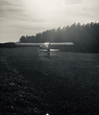
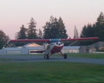
We are big time now
-
- 100+ Posts
- Posts: 748
- Joined: Sun Jul 14, 2013 12:24 pm
- Location: Central LA
- Contact:
Well, looks like I'm not making the chart
RICHMOND PLANTATION
Existing grass runway 11/29,
2,300 ft. total length
Forrest Hill, LA 31-03-10.10N 92-37-55.60W 150
We have completed an airspace analysis of the proposed private use airport. As studied, the location is approximately 6 nautical miles Southeast of Forrest Hill, LA.
* Use of this airport is restricted to the following 1. Day/VFR only 2. Use by owner or with owner's permission. 3. Operations at this airport are highly challenging due to the vegetation height at runway ends and obstacle penetration on the 20:1 approach slope for utility and visual runways. Operations can be conducted safely by a pilot with the appropriate experience and equipment. To discourage unauthorized use, this airport should not be charted. 4. Owner will provide thorough briefing about operational requirements and vegetation height at runway ends prior to anyone desiring to use this airport.
I can't remember if I fired six shots, or only five.....
M-5 220c, circa 1974
EAA #428061
M-5 220c, circa 1974
EAA #428061
- gbarrier
- 100+ Posts
- Posts: 1562
- Joined: Thu Jul 14, 2011 5:41 pm
- Location: 9NR4 North Carolina
- Contact:
Well that sucks. Kind of sounds like mine or Captnkirk's place. I have 1500 ft with a gap in the trees on one end and power lines above the runway at the other. I'll let Kirk tell you about his. Every office is different. At least it will be registered. Am sure you will give us the "appropriate briefing" when we come calling.
- captnkirk
- 100+ Posts
- Posts: 942
- Joined: Wed Dec 25, 2013 4:54 pm
- Location: Cherryville NC
- Contact:
Pilot you have more runway then either Gary or I. Counting the gap at one end of my place I have maybe 2000 ft and only about 1500 usable Plus both of us have some "vegetation " at one or both ends and maybe a power line to think about. Then there is the slope, has to be some wind to make me land downhill. I think I would tell who ever wrote that, your friends want it on the map cuz they think it's a hazard because all those spam cans can use it. Heck you may even need a control zone and a tower. Seriously tell them you want it charted so other aircraft will look for your airplane, trying to be proactive with see and avoid stuff. Good Luck
Kirk Johnson
If god had meant man to fly he would have given him more money
- FARMAULE
- 100+ Posts
- Posts: 194
- Joined: Wed Oct 24, 2012 1:31 pm
- Location: West Virginia
- Contact:
- gbarrier
- 100+ Posts
- Posts: 1562
- Joined: Thu Jul 14, 2011 5:41 pm
- Location: 9NR4 North Carolina
- Contact:
- Andy Young
- 100+ Posts
- Posts: 1548
- Joined: Wed Oct 05, 2011 7:10 am
- Location: Alaska, Antarctica, Colorado, and Others
- Contact:
Yeah, it seems like with those criteria, half the charted airports in Alaska would have to be pulled off the charts.
One of my favorites, in terms of craziest charted airports, is Z86, Clearwater, Alaska. It's been pulled off the chart now, but that's only happened in the last few cycles. Up until then, it was on there as long as I can remember. The entry in the Alaska Supplement (Alaska's version of the AFD) for that airport read:
Runway: 25/07: 350' x 20'
Surface: Gravel/dirt, poor condition, soft and irregular; rocks to 6" on runway, scattered brush and trees to five feet throughout runway.
Remarks:
Scattered brush and trees to eight feet from edge to 35' from centerline each side of runway full length.
Runway surface totally overgrown with trees up to 15' tall.
Scattered trees to 30', 40' from centerline each side of runway.
Scattered trees to 40' approach path runway 25.
Scattered trees to 20' approach path to runway 07.
Brush and trees to five foot across width of runway at a point 350' from runway 07 threshold.
Campfire rings at runway ends.
Runway used as road.
Barrel; rock pile and debris at center of runway 50' from runway 25 threshold.
Runway high in middle, slopes down both directions.
If that one made it on the charts and stayed there for years, it seems like yours should be acceptable .
- captnkirk
- 100+ Posts
- Posts: 942
- Joined: Wed Dec 25, 2013 4:54 pm
- Location: Cherryville NC
- Contact:
Farmmaule the 2 faa forms I had to send in where 7480 Notice of Landing Area and 5010 Airport Master Record there was one more but that was a NC state form which would not apply to you. Again check with your state DOT they may have some to help.
Kirk Johnson
If god had meant man to fly he would have given him more money
- chazdevil
- 100+ Posts
- Posts: 222
- Joined: Fri Sep 18, 2009 10:31 am
- Location: gone flying
- Contact:
Runway description
Runway: 25/07: 350' x 20'
Surface: Gravel/dirt, poor condition, soft and irregular; rocks to 6" on runway, scattered brush and trees to five feet throughout runway.
Remarks:
Scattered brush and trees to eight feet from edge to 35' from centerline each side of runway full length.
Runway surface totally overgrown with trees up to 15' tall.
Scattered trees to 30', 40' from centerline each side of runway.
Scattered trees to 40' approach path runway 25.
Scattered trees to 20' approach path to runway 07.
Brush and trees to five foot across width of runway at a point 350' from runway 07 threshold.
Campfire rings at runway ends.
Runway used as road.
Barrel; rock pile and debris at center of runway 50' from runway 25 threshold.
Seriously.
That's my favorite description yet.
79 M5 235Turbo
- captnkirk
- 100+ Posts
- Posts: 942
- Joined: Wed Dec 25, 2013 4:54 pm
- Location: Cherryville NC
- Contact:
Pilot, Andy made a video going into my place if you look close you can see the trees on both ends. I have cut out some clearway but it is still full of stumps and unusable. Andy landed to the north which is up hill and when he left he took off south down hill. Notice he only used a bit over half of the runway and less on take off. Again the grass is only 1500 ft. so plenty of room for the right kind of aircraft. So tell your fed that normal operations can be safely conducted on your place.
Kirk Johnson
If god had meant man to fly he would have given him more money
- captnkirk
- 100+ Posts
- Posts: 942
- Joined: Wed Dec 25, 2013 4:54 pm
- Location: Cherryville NC
- Contact:
here is another link to Andy's video
https://youtu.be/RIeTE4xxChI
Kirk Johnson
If god had meant man to fly he would have given him more money
- riverbuggy
- 100+ Posts
- Posts: 172
- Joined: Tue Dec 21, 2010 5:26 pm
- Location: Sidney, Maine
- Contact:
-
- 100+ Posts
- Posts: 748
- Joined: Sun Jul 14, 2013 12:24 pm
- Location: Central LA
- Contact:
- captnkirk
- 100+ Posts
- Posts: 942
- Joined: Wed Dec 25, 2013 4:54 pm
- Location: Cherryville NC
- Contact:
- gbarrier
- 100+ Posts
- Posts: 1562
- Joined: Thu Jul 14, 2011 5:41 pm
- Location: 9NR4 North Carolina
- Contact:
- riverbuggy
- 100+ Posts
- Posts: 172
- Joined: Tue Dec 21, 2010 5:26 pm
- Location: Sidney, Maine
- Contact:
Who is online
Users browsing this forum: No registered users and 15 guests